Cartographic Archaeology: How Modern GIS Is Resurrecting America's Lost Roads and Abandoned Transit Networks
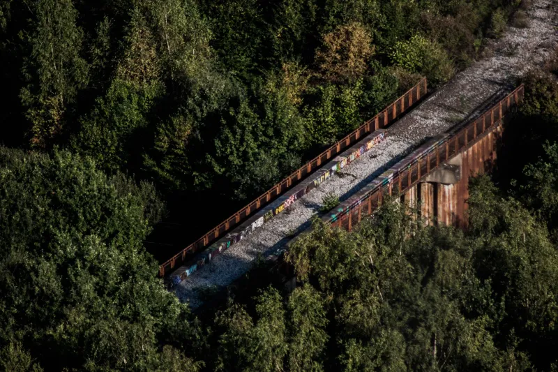
America's landscape is layered with memory. Beneath the surface of contemporary maps — those clean, satellite-derived renders that populate navigation apps and municipal planning dashboards — lies a palimpsest of forgotten movement. Wagon routes that preceded the railroad era. Electric streetcar lines that were dismantled in the mid-twentieth century. Logging roads carved into Appalachian hillsides that nature has since reclaimed. These are not merely historical curiosities. For GIS analysts, urban planners, and economic development specialists, they represent a recoverable spatial intelligence with measurable modern value.
The emerging discipline sometimes called cartographic archaeology uses geospatial technology to detect, catalog, and interpret abandoned transportation infrastructure. What was once the province of local historians and railroad enthusiasts has become a rigorous analytical practice, one that is influencing decisions about trail development, freight logistics, broadband corridor routing, and neighborhood revitalization across the United States.
Reading the Land Through LiDAR
No tool has done more to accelerate the detection of lost infrastructure than LiDAR — Light Detection and Ranging. Mounted on aircraft or drones, LiDAR sensors emit millions of laser pulses per second, measuring the precise distance to the ground surface. The resulting point cloud data can be processed to generate bare-earth elevation models that strip away vegetation and reveal subtle topographic features invisible to conventional aerial photography.
A decommissioned rail bed, for instance, typically leaves a characteristic signature in the landscape: a linear embankment of consistent width, often accompanied by the remains of drainage ditches on either side. Even after decades of overgrowth, these features register clearly in LiDAR-derived hillshade models. The same principle applies to old plank roads, corduroy paths laid across wetlands, and even Native American trade routes that European settlers later formalized into colonial-era highways.
The USGS 3D Elevation Program (3DEP) has made high-resolution LiDAR coverage increasingly available across the continental United States, dramatically lowering the barrier for local governments and university research teams to conduct this kind of analysis. Datasets that once required specialized procurement contracts can now be accessed through public portals and integrated directly into platforms such as ArcGIS Pro or QGIS.
Historical Maps as Spatial Evidence
LiDAR tells analysts where the land has been disturbed. Historical cartography tells them why. The combination of both data sources is where the most compelling analytical work is happening.
The Library of Congress's Geography and Map Division holds tens of thousands of digitized historical maps, many of which document transportation networks that no longer appear on any contemporary dataset. Sanborn fire insurance maps, originally produced to assess urban risk, incidentally captured street-level infrastructure detail for thousands of American towns between the 1860s and 1950s. General Land Office survey plats from the nineteenth century recorded roads and trails at the time of federal land survey, many of which were subsequently abandoned as settlement patterns shifted.
GIS analysts are georeferencing these historical documents — aligning them to modern coordinate systems — and overlaying them against current basemaps and LiDAR data. The result is a layered spatial record that allows researchers to trace the evolution of a transportation network across time. In several documented cases, this process has revealed that what appears on a modern map as a gap in the road network was once a continuous corridor, severed by highway construction, suburban subdivision, or institutional land acquisition.
Case Studies in Rediscovery
The Rails-to-Trails Conservancy has long championed the conversion of abandoned rail corridors into multiuse paths, and GIS analysis has become central to that mission. In Pennsylvania's Wyoming Valley, spatial analysis of historical railroad atlases combined with current parcel data helped planners identify a continuous right-of-way threading through multiple municipalities — one that had been functionally invisible because no single jurisdiction maintained a complete record of it. The resulting trail project connected communities that had been spatially fragmented for decades.
In the rural South, researchers working with county governments have used GIS to recover networks of historic farm-to-market roads that were removed from official maps when state highway departments standardized their classification systems in the 1950s and 1960s. Some of these corridors, though overgrown, retain legal right-of-way status embedded in deed records — a discovery with direct implications for agricultural access, emergency vehicle routing, and broadband infrastructure deployment.
Urban applications are equally compelling. In several Midwestern cities, municipal planners have used historical streetcar route data — digitized from transit commission archives and georeferenced against current street networks — to inform bus rapid transit planning. The logic is straightforward: those corridors were originally designed to move large numbers of people efficiently, and the urban morphology they shaped — denser development, mixed-use blocks, pedestrian-scaled streets — often persists even where the transit infrastructure does not.
The Data Challenges That Remain
The work is not without its complications. Historical maps are not always accurate, and the process of georeferencing introduces its own margin of error. Parcel records, deed archives, and right-of-way documentation are frequently held by different agencies with incompatible data formats and inconsistent digitization standards. In many rural counties, critical records exist only in paper form, requiring manual review before spatial analysis can begin.
There is also the question of jurisdictional complexity. A recovered corridor may cross land held by federal agencies, state governments, private landowners, and tribal nations — each with distinct legal frameworks governing access and use. GIS analysis can identify the physical path of a forgotten road, but translating that discovery into actionable planning requires legal research, community engagement, and interagency coordination that no mapping tool can automate.
Privacy considerations add another dimension. In some cases, the recovery of historical infrastructure reveals information about land use patterns, property boundaries, or community histories that affected landowners may contest or that require sensitive handling — particularly where Indigenous land rights or historically discriminatory planning decisions are implicated.
Infrastructure Memory as Planning Resource
Despite these challenges, the momentum behind cartographic archaeology is growing. State DOTs, metropolitan planning organizations, and rural economic development agencies are increasingly recognizing that the spatial record of past infrastructure decisions is itself a planning asset — one that took generations to accumulate and that no amount of new survey work can fully replicate.
The broader implication is significant. American infrastructure investment tends to be framed as a problem of building new capacity. But the geospatial record suggests a complementary opportunity: recovering, reactivating, and adapting what already exists in the landscape, even if it has been forgotten by every agency that might have been expected to remember it.
For GIS professionals, this represents a distinctive and consequential application of spatial analysis — one that looks backward through the cartographic record in order to inform what gets built next. The ghost roads of America are not simply relics. In the right hands, with the right tools, they become data.